
“…Whereas the People of Trinidad and Tobago—…(b) respect the principles of social justice and therefore believe that the operation of the economic system should result in the material resources of the community being so distributed as to subserve the common good…”
From the preamble of our Republic’s current Constitution (1976)
The simple truth is that the overwhelming majority of HDC’s applicants can only afford to rent, but nothing is being built for rent. That is the challenge we face in terms of realising the objectives of our Housing Policy.
I thought this would be a two-part analysis, but the final conclusions required a fuller treatment, hence this closing article to place those issues in a public policy context. My analysis led me to the conclusion that the HDC’s projects could not in any way have satisfied a proper needs assessment, as required by the Public Procurement and Disposal of Public Property Act (PPDPPA). As such, this is a call for the OPR to engage these public policy issues with the required seriousness.
The current state of play in this arena of Housing Policy and its originating Statute, operating within the PPDPPA, is plainly one in which the precept of ‘Value for Money’ is being routinely violated. HDC is a Statutory Agency, yet its vast capital spending is done in contradiction to its statutory obligations, which is the basis for my challenge as to its ability to support any value for money claims. Notwithstanding the claims of this economy or that new approach, if the HDC’s projects do not satisfy the required needs assessment, that serious failure must be the only reasonable conclusion.
These policies, laws and public agencies were intended to provide decent, affordable homes to the poor citizens in our country, in recognition of the ideal that social justice was an essential ingredient of a modern, progressive society. The historical context must first be established to understand what is at stake here.
The Housing Act, which was Act 3 of 1962, passed on August 3,1962, even before our formal Independence, which shows the importance placed on affordable housing, even in the ‘bad old days’. That Act established the National Housing Authority, which absorbed all the previous public housing agencies. Our legislators, in preparing that Act, took the care, in Section 2, to include proper definitions for –
- “family of low income” means a family that receives a total family income that, in the opinion of the Authority, is insufficient to permit it to rent housing accommodation adequate for its needs at the current rental market in the area in which the family lives;
- “low-rental housing project” means a housing project undertaken to provide decent, safe and sanitary housing accommodation complying with standards approved by the Authority, to be leased to families of low income or to such other persons as the Authority, under agreement with the owner designates, having regard to the existence of a condition of shortage, overcrowding or congestion of housing;
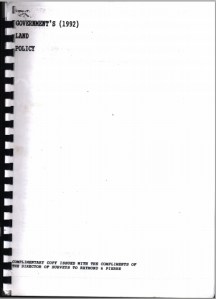
The 1992 Land Policy established strong guidelines on how our limited supply of land should be developed –
Conclusion of the 1992 Land Policy10.1 A small State such as Trinidad & Tobago must accord a very high priority to the judicious management and utilization of its land resources or perish. All elements of land policy must be designed to ensure that these finite resources are efficiently utilized and husbanded in such a manner as to serve the long term interests of the national community…
That chimes readily with the precepts of our Constitution, yet here we are, with sites being located and approved for large-scale development of new homes, all to be sold. One can scarcely recall any such official statement about sites for new homes for rent.
The 2002 Housing Policy set out the challenge of properly housing citizens who cannot afford to buy a home, and that Policy led directly to the HDC Act.
The HDC Act of 2005 – This Act established the Housing Development Corporation, which is mandated by Section 13 to create affordable homes for low and middle income applicants. The sequence intentionally sets a priority for low-income applicants, but here we are.
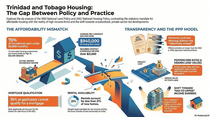
The CSO Statistics – 70% of our households have a monthly income of less than $9,000, according to the most recent CSO research (the 2011 census).
HDC Research – Many official statements confirm that over 95% of the applicants on the HDC’s waiting-list cannot qualify for a mortgage, simply because they are too poor. My research shows that only 21% of new HDC homes are available for rent. When one considers the Policy and Statutory requirements, we are witness to an unpardonable, ongoing misallocation of vast State resources of Land and Capital. This is a case of sly erasure, in which established public policy and statutory obligations were erased to facilitate routine violations by the responsible state agency.
Over 95% of applicants cannot qualify for mortgages, yet roughly four-fifths of new HDC construction is aimed at ownership rather than rental, so the State is structurally producing new homes beyond the reach of those applicants.
HDC’s decision to pursue this approach to the public housing program, in violation of its statutory obligations, has had the result of fortifying the position of the middle class, all at the expense of the lower-income citizens for whom these provisions were established. That is the class war at work in this large-scale program.
Having set the public housing background, the needs assessment issue must be engaged to understand how these projects, none of which could possibly have satisfied a proper needs assessment, could be compliant with OPR requirements. The only way that practice could prevail is if challenge proceedings issued to the OPR are limited to disgruntled competing contractors or party-political issues, which is exactly what is happening. Such challenges would never trigger a sober examination of the actual basis of these projects.
The OPR has an overarching responsibility to ensure value for money, but this analysis illustrates that, despite the encouraging engagement of challenge proceedings and the timely disposal of those, there is still a sobering gap in terms of achieving the established statutory targets. Even though no numbers are explicitly stated in the HDC Act, it is clear from this analysis that there is a major issue in terms of those statutory objectives being breached by these projects.
So what should be the OPR’s role in this matter? The clear objective of the policy is to provide affordable homes to lower and middle income applicants, yet that is not being achieved. The limited grounds upon which challenges are engaged is only a part of the issue here. More importantly, there is a way that a purely project-based approach to project review does not at all serve the wider public interest and in fact can permit this unacceptable situation to persist. If needs assessments are only being prepared with respect to particular projects, there is every danger that this quiet evasion of the HDC’s statutory obligations will continue, to the detriment of the lower-income citizens it was established to serve.
A legitimate housing needs assessment would necessarily compare applicant income distribution, mortgage qualification rates, rental demand, household size, geographic need, and long-term affordability before project typology is selected.
The OPR needs to engage this question since there is a clear prospect of Public Money being placed at peril since it is being spent in violation of the HDC’s statutory obligations. The stakes are high and we must be determined in developing a new understanding of the intersection between Housing Policy and the PPDPPA if we are to ensure ‘Value for Public Money’.
The calculated silence and erasure of our progressive public housing policy must be unmasked and resisted if we are to realise the ‘principles of social justice so that the operation of our economic system results in the material resources of the community being so distributed as to subserve the common good’, as cited in our Constitution. The HDC must serve our poorest citizens for whom these systems were created.


 Land Settlement Agency – Stated that they were unaware of any official land policy in existence and suggested that we contact the Ministry of Planning & Sustainable Development.